“in the escalante desert”
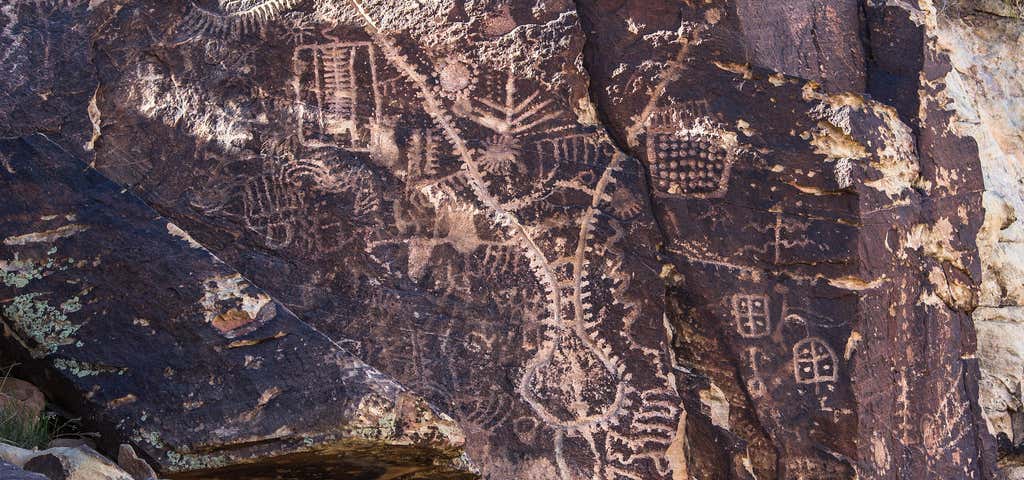
Approximately 15 million years ago, a long slender section of sedimentary rock sheared from the earth's crust along parallel fault lines. This up-thrown block, later named the Red Hills, began to inch its way above the surrounding valley floor. At the same time the block was rising, a stream was cutting a path perpendicularly across the ridge. For millions of years the uplifting of the ridge and the down-cutting of the stream remained in equilibrium. Eventually however, the relentless rise of the ridge and the drying of the region's climate combined forces to defeat the stream. The stream disappeared and the valley became a waterless wind gap. Continued erosion by wind and rain have shaped the gap into the pass seen today. Parowan Gap Petroglyphs Several centuries ago Native Americans traveling through the area stopped and pecked designs onto the smooth faces of large boulders found on the east side of the gap. Over the years many of the boulders have been covered with these chiseled figures known as petroglyphs. The petroglyphs here are thought to be the work of several cultural groups and represent a long period of use by Native cultures. What these designs mean is still unknown. Archaeologists debate that they represent concepts, ideas or actual happenings. Perhaps they were part of a religious activity or hunting ritual. The local Native Americans consider them to be an important part of their cultural history relating stories of their ancestor's lifeways. New dating techniques are being developed that will allow petroglyphs to be placed in time. While we don't know the precise age of these petroglyphs yet, we do know that the agriculturally based Sevier-Fremont lived in the area over a thousand years ago. There is little doubt that some of the designs were made by this group, or perhaps even the earlier nomadic Archaic peoples. Researchers believe that the semi-nomadic ancestors of the present day Southern Paiute also created some of these figures. The Parowan Gap Petroglyphs are listed on the National Register of Historic Places signifying its importance as a cultural treasure. When sites are damaged in any way, much of what they can tell us is lost forever. Please tread lightly, causing as little disturbance as possible. Rock art should be photographed or sketched but not touched in any way. Fingers and palms leave oils that speed deterioration. Chalking the figures will eliminate the chance to use new dating techniques in the future. Laws with stiff penalties have been enacted to protect our past. But each of us have a responsibility to help preserve this and other archaeological and historically significant sites. Please report any vandalism to the local BLM Office or Sheriff. Parowan Gap Parowan Gap has two features of distinction, one natural, one man-made. The pass near Parowan is a classic example of a wind gap, an unusual geological landform marking where an ancient river has cut a 600-foot-deep notch through the Red Hills. Secondly, the gap is a nationally recognized extravaganza of petroglyphs--a superb "gallery" of Native American rock art. Here one can witness what is at least a 1,000 year accumulation of artwork pecked into the rock. Geometric designs, images of lizards, snakes, mountain sheep, bear claws and human figures adorn the smooth canyon walls of the pass. These features, set amidst the vast panoramas of the Escalante Desert make for a fascinating getaway located just a few miles off the interstate mainstream.
Reviews of Parowan Gap Petroglyphs Dispersed Camping
3 people have reviewed this location
Ratings Summary
Reviews

A must-see! About 9 miles off I-15. Take exit 78 and turn east towards Parowan (N Main). In about 0.5 mile turn right on W 400N which will take you back west under the interstate (turns into Gap Road) and out to BLM land (paved, thus easily accessible by 2WD low clearance vehicles). There is also a dinosaur footprints site but I thought this was underwhelming when compared to the petroglyphs! There are too many to count. Many are fenced off but there are some you can walk up to. Remember not to touch them and only take pictures. Do not carve your name into the rock. I unfortunately saw some vandalism dated the same day I visited :( Please make sure many others can enjoy this site for many years to come and just don't touch! Interpretive displays show the different interpretations of the different petroglyphs. There is a vault toilet at this site.

Definitely worth the detour. Google or apple maps for exact location. Location on here is slightly off. From I-15 continue on gravel pit road towards the hills and you will see Parowan Gap with a parking area.

Looks like this is Bureau of Land Managment land, so camping is primative, but free.

This place is so cool despite the many more recent addictions (read: graffiti and/or vandalism). Definitely see the glyphs more easily on the parking lot side of the gap, but make the effort to find them on the other side too.
Be the first to add a review to the Parowan Gap Petroglyphs Dispersed Camping.
/-112.9843129,37.9093089,14/300x172@2x?access_token=pk.eyJ1Ijoicm9hZHRyaXBwZXJzIiwiYSI6ImNsdjQ5N2VtZDA2bW8ycW13ZHAxeGhjbjkifQ.UIccpoAxc7g3BAuK4s9vjg)
Parowan Gap Petroglyphs Dispersed Camping
Hours
Problem with this listing? Let us know.
Has RV parking changed? Let us know.
-
Parking
-
Pets Allowed
-
Restrooms
-
Wifi
-
Wheelchair Accessible
-
Credit Cards Accepted
- Max Stay
- 14
- Affiliation
- Bureau of Land Management (BLM)
-
Fifty Amp
-
Tent Sites
-
Full Hookup
-
Paved Sites
-
Sewer Hookup
-
Water Hookup
-
Standard Tent Sites
Campground
Nearby Hotels
Related Trip Guides
- Trip Guide
Pay Tribute and Reflect at These US Monuments and Memorials
- 14 Places
- Trip Guide
The ultimate road trip guide to Canyonlands National Park
- 18 Places
- Trip Guide
How to best experience Zion National Park
- 15 Places
- Trip Guide
Road trip to the filming locations of 'Dumb and Dumber'
- 8 Places
- 41:01
- 2,643 mi